| 899 | Gregory Bald Trip Notes |
2014-01-16 |
Gregory Bald area was new to me. So for a few notes about the trails, camping, mountain, and the trip (hopefully, I did not repeat too many notes from the Trip Report.) ...
Jon had been to Gregory Bald several times. He used the trail, which climbs 3600 feet, as a training hike. He sold us on visiting the area. It was a good choice.
Gregory Bald is in the western half of the Park. It is located on the main ridge line or crest of the Smokies between Cades Cove to the north and Cheoah Lake (the outflow of Fontana Dam) to the south.
Jon declared the Cades Cove route too busy, so we (Jeff, actually) booked reservations from the Twentymile Creek Trailhead.
To get to Twentymile from Middle Tennessee, we had to pass through Maryville and then head south to the shores of Cheoah Lake. Turning east we followed Hwy 129, the famous Dragon, east to Deal's Gap and then continued on Hwy 28 to Twentymile Creek Ranger Station and Trailhead.
Jon lamented that he wished he was driving his Mini-Cooper on the sporty road, but I was fine riding in a not so fast vehicle.
On Friday, there was not a lot of traffic on the Dragon. We did however see a band of wild hogs (at least three) crossing the road and heading toward the Park.
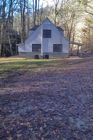
A sign indicates the turn to the Twentymile Creek Ranger Station. the entry a gravel road that leads to a white house. I have driven by the entrance quite a few times, but have never really took note of the Ranger Station. The station is only barely visible from Hwy 28.
Parking is available near the Ranger Station (house). One small lot is available before the house and another just a short distance beyond the house.
A gate closes the gravel road.
Twentymile Trailhead elevation is 1320 feet.
At the trailhead, we found a trail kiosk, maps for sale for $1, an emergency phone, and a couple of picnic tables.
The map is a good map for mileage and as a general Park location tool, but it is not a navigation map.
There are no restrooms or potable water at the trailhead.
It is an easy .55 mile (depending on where you actually start) along Twentymile Creek to the junction with Wolf Ridge Trail.
Twentymile Cascade is a short distance from the junction while staying on the Twentymile Trail (bear right at the junction).
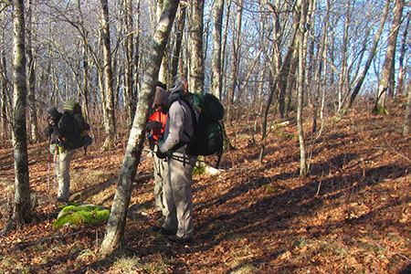
The Twentymile Trail continues as a gravel road. At times the road climbs steeply.
Good bridges cross over all of the creeks on the gravel road until it reaches Proctor Field Gap.
At 1.75 miles from the trailhead is Campsite 93 - Twentymile Creek. The campsite is located adjacent to the trail.
Hiking toward Proctor Field Gap, we saw a man dressed in camouflage and carrying a weapon (rifle). He was actually a Park worker (possibly a Ranger) who was hunting wild hogs. Hmmm.
The Proctor Field Gap Junction is at 3.05 miles. It connects the Twentymile Trail, Twentymile Loop Trail and Long Hungry Ridge Trail.
The Twentymile Trail continues to the east. We did not walk it.
The Twentymile Loop Trail goes to the west. We did not walk it.
The Long Hungry Ridge Trail leads just to the right of the Loop Trail and was our route to Gregory Bald Trail.
The Long Hungry Ridge Trail is an unmaintained road for most of it's length.
On the Long Hungry Ridge Trail, shortly after Proctor Field Gap, the path drops down off road and contours to Proctor Branch, a creek crossing.
On the other side of the creek, the path rejoins the unmaintained road. I am assuming - there used to be a bridge across the creek that has long since disappeared.
Several more creeks cross the road before reaching the Upper Flats Campsite - number 92. The Campsite is 1.10 mile from Proctor Field Gap.
Site 92 is on the banks of Greer Branch. It is a large camping area. There are no facilities other than the food storage cable systems (2).
We carried a large tarp (MSR Zing) on the trip. It gave us a nice group area to sit out the evening and morning rains.
On Saturday morning, we delayed our departure until after the rain passed. The forecast was actually correct! Oh, for a good mountain weather site try Mountain Forecasts.
We had a significant storm move through and were faced with high water at all of the creek crossings. Trekking poles helped with the crossings.
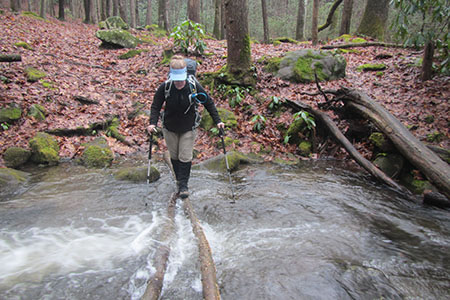
Leaving Site 92, we crossed Greer Creek. Some of our group waded across while others walked the logs. Walking the logs was quicker, but if you mis-stepped it would have been wet!
A quarter of a mile from the Greer Creek crossing, the trail crosses Twentymile Creek. This crossing was much deeper than Greer. To cross, we would have to either construct a log bridging system, wade, or wait for the water level to recede. We waded. For a short section of the crossing, there was a stiff current.
The Long Hungry Trail leaves Twentymile Creek and climbs along Rye Branch for .40 mile, and then, another crossing. The Rye crossing is much easier than the other two (Greer and Twentymile Cr).
Rye Creek is the last water until Moore Spring (side trail) or Sheep Pen Gap (down Gregory Bald Trail).
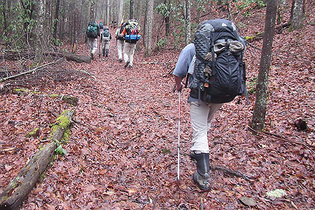
The Long Hungry Ridge Trail continues to follow an old road as it climbs steeply to the actual Long Hungry Ridge at Rye Patch.
Rye Patch is 1.85 miles from the Rye Creek crossing, 2.50 miles from Campsite 92. It is a great place to take a break!
It is .95 mile from Rye Patch to Gregory Bald Trail. The Long Hungry Trail ends at the junction.
Rich Gap at just over 4600' is 0.05 mile to the west from Long Hungry Trail.
At Rich Gap carved in a sign is H20 and an arrow to the left or southwest. The side trail bypasses a short section of trail and visits Moore Spring. We did not visit the spring, but will on our next visit. The trail returns to the Gregory Bald Trail in a gap before the climb up Gregory Bald.
Back at Rich Gap, Gregory Ridge Trail leads to the north as it descends Gregory Ridge and Gregory Bald Trail climbs very steeply along the ridge.
The final climb to Gregory Bald is the next rise. It is not as steep as the climb out of Rich Gap.
A side trail to the north leads to an overlook, but it is not better than the view from the top.
The summit is not far. There are really good views of Cades Cove to the north and Fontana Lake to the south.
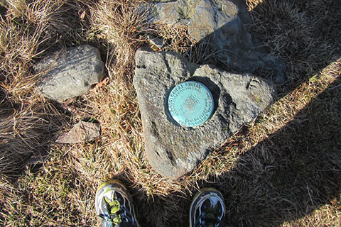
A triangular stone holds the benchmark at the summit.
The freeze-thaw cycle at the higher elevations led to a slippery, muddy, trail in the winter.
Sheep Pen Gap is at the bottom of the hill to the west. The feature seems more shoulder like, than a gap. There is a gap to the southwest, on the way to Parson's Bald. I think that is the real Sheep Pen Gap.
The Gregory Bald Trail (from Cades Cove via Sams Gap and Parsons Branch Rd)) and Wolf Ridge Trail (from Twentymile) intersect at Sheep Pen Gap.
Campsite number 13 (Sheep Pen Gap) is at the junction.
Water for the camping area is down the Gregory Bald Trail, a little over 0.10 mile away. The drainage/creek runs over the trail.
Sheep Pen Gap is a large camping area. It is not protected from the wind.
Wolf Ridge is a great trail.
The upper trail was frozen. The footing was excellent, as compared to the previous evenings' slippery slopes.
Wolf Ridge is a dual use, hiking and horse trail. Despite the dual use, the trail was in very good shape.
The climb to Parson Bald feels good on a cold morning. The bald is 0.75 mile from Sheep Pen Gap Campsite.
Parson Bald is not as open (bald) as Gregory Bald. Still there were views.
The Wolf Ridge Trail is more trail like, than Long Hungry Ridge which was just an old road. Wolf Ridge actually has switchbacks and follows a great route as it descends to Dalton Creek.
The trail crosses several small creeks on the descent. There is also a spring running next to the trail. The spring is about 3 miles from Sheep Pen Gap Campsite at about 3200 feet elevation (1.5 miles from Dalton Branch).
Dalton Branch Campsite (95) is not visible from the trail, but it is in a great location. We did not visit the site.
Dalton Branch is 3.65 miles from Parson Bald and is 2.45 miles to Twentymile Trailhead. The elevation is almost 2,200 feet.
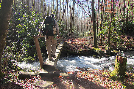
We were concerned about creek crossings along Dalton Branch and Moore Spring Branch. The trail stays north of Dalton Branch and Moore Spring Branch is crossed on footbridges. There are 5 crossings.
Special measures would be needed to cross the footbridges with children.
Back at the trailhead, our vehicle was untouched and there were no signs of any break-ins (broken glass) in the area. The parking area being located near the Ranger Station probably helps deter would be no gooders.
The drive out on the Dragon was exciting. There were many motorcyclist testing there skills on the curves. Zoooom!
We returned to Maryville by taking the Foothills Parkway. The Parkway has great views of the Smokies.
The Gregory Bald hike is a good adventure. From Twentymile Trailhead, either trail could be taken as a long day hike or overnight hike. Long Hungry Ridge and Wolf Ridge could be hiked individually as an out and back or done as a loop.
We plan to return soon and hike the trails starting in Cades Cove area - the Gregory Bald Trail and Gregory Ridge Trail.
Thanks to my friends for the great hike and introducing me to Gregory Bald.
Happy Gregory Bald trails