| 912 | Wolf Ridge Trail Guide Gregory Bald - Smokies |
2014-03-14 |
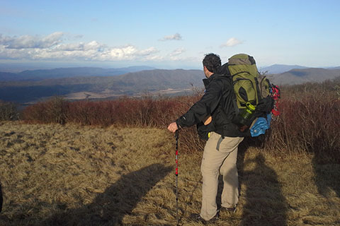
In January I had the opportunity to join a group to hike Gregory Bald in the Smokies. We hiked up the Long Hungry Ridge Trail, crossed Gregory Bald and then descended Wolf Ridge Trail. It was a worthy adventure.
Gregory Bald is not one of the high, above 6,000 feet, east of the Mississippi, peaks, instead it is a lowly 4,949 feet. Oh, but don't feel sorry for it's diminutive stature, because Gregory Bald is still a good climb. Let me explain. When peak bagging, there is always some kind of qualifier that must be asserted to level the playing field for all participants. For example, is it okay to drive to the top of a mountain instead of hiking to the top? Well, if you have to hike, how far and how much elevation do you have to gain? And, when is a mountain a mountain?
Gregory Bald unofficially climbs (net) 3,629 feet from Twentymile Trailhead and 2,989 (net) from Cades Cove - Gregory Ridge Trailhead. There are Colorado 14,000 feet peaks that have less net gain from natural trailheads than the Gregory Bald climbs. Gregory Bald is a mountain.
We hope to soon have guides to all four major trails of Gregory Bald. But, we are now happy to announce the Wolf Ridge Guide is completed on cloudhiking.com.
So for a few Wolf Ridge notes ...
Using the enjoyable Long Hungry Ridge as a baseline, we thought that Wolf Ridge was at least as good!
Long Hungry Ridge and Wolf Ridge share the same trailhead and the first 0.55 mile of trail (from the trailhead kiosk at the Ranger Station to the junction of the Wolf Ridge Trail).
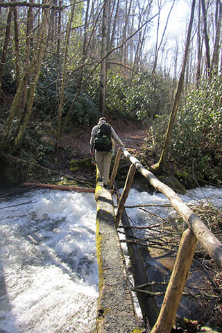
The hike along Moore Spring was very nice. It was an easy grade and footbridges were at each stream crossing. Of course, in the summer it might be more fun to wade across a stream than in the winter when we hiked the trail. In the winter the footbridges were nice.
The footbridges were sturdy, but the tread was worn and the handrails leaned away. Use caution!
The campsites along the trail were great. Dalton Branch Campsite was close to the stream and Sheep Pen Gap was high on the shoulder of Gregory Bald.
It is a good climb to Parson Bald. The grade was steep enough to use three sets of swithcbacks.
A small spring is passed at about 1.35 miles from Dalton Branch.
Parson Bald offers good views of the final goal Gregory Bald.
From Parson Bald the trail descends to Sheep Pen Gap. The actual gap is not where the campsites and trail junction are located. They are 0.10 mile away.
From the Sheep Pen Campsites, water is available a short distance down the Gregory Bald Trail. The stream crosses the trail.
Back at the junction, Gregory Bald is 0.40 mile to the east.
There are great views from the Bald at 4949 feet!
The hike is 7.20 miles, one-way.
Be sure and visit cloudhiking.com and view the guide. Thanks!
Happy Gregory Bald Wolf Ridge trails
Thanks Jon for the photo