| 217 | Vaughn Creek Cross Country Course |
2010-04-19 |
Sunday, my friend Jon and I went to Percy Warner Park in Nashville to record the Vaughn Creek Cross Country Course. Jon used to run cross country and was going to help guide me through the maze of paths.
Parking at the trailhead on Highway 100, we started by checking out the kiosk. The posted map made no sense to me. It was basically lines on a sheet of paper without reference points. Not to worry though, Jon would show me where to go.
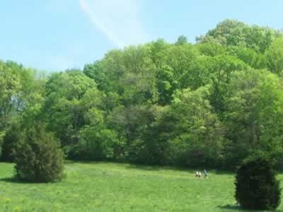
We had fun deciphering the route and recording it with the gps(s) and camera. The course is used for multiple events with varying lengths. We therefore decided, there was no correct route. We logged the outside path, with no overlaps, as 2.25 miles or 3.62 kilometers. We actually walked 3.2 miles exploring the route.
Back at the kiosk the map made more sense. We did not do the posted 4 kilometer route, but we did understand how the route was laid out.
A few trail notes ...
- The parking area is adjacent to Highway 100. Security should be better than in the not so exposed areas of the Park.
- There are no facilities at the trailhead. (The Nature Center at Edwin Warner Park is the closest.)
- There is no water at the trailhead.
- Most of the trail would be exposed to the afternoon sun. It looks hot.
- We saw quite a few runners and hikers using the trail.
- There were quite a few dogs on the trails also.
- There were no blazes used to mark the route. Occasionally there were pieces of orange survey tape tied to a limb or bush as indicators. The course changes due to the varying lengths and is probably marked by the coaches and officials for each event. The route does follow a good worn path.
- Cedar trees are used as course markers.
- There were mileage (or kilometer) posts which were a bit confusing. I am sure they matched the actual course route; but to me, they were just random numbers!
- The path comes near or crosses the Park Road, the Mossy Ridge Trail (blazed red), and the Cane Connector Trail (red and white stripped). It would be easy to extend the mileage of the route.
- The kiosk also had tips on running and stretching for anyone needing a refresher.
The Vaughn Creek Cross Country Course makes a good run or hike. It would be ideal for those who would like to trail run someday; but for now, feel more comfortable on the road.
Happy cross country trails.
for more info ...