| 606 | Fall Creek Stories | 2012-03-23 |
Wednesday, we visited Fall Creek Falls State Park for the day. Hiking on most of the trails in the central part of the park, we met alot of hikers and have a few stories...
Amy, my wife, is leading an outdoors school trip to Fall Creek in a few weeks. Since we were going to the Park for a hike anyway, we were also going to drive the same route she was going to drive in the mini-school bus to visit the group lodge where they are supposed to stay. We normally drive on a winding country road that leads to the north entrance to the Park. She does not want to drive the school bus on a secondary road. Instead she is going to follow the major highways to the south entrance.
Over the years we have traveled the route to the Park many times. Even though we normally use the other entrance, we are still familiar with the main route too.
As we traveled we talked about upcoming trips and plans. Driving, I noticed road construction as we drove through Spencer and then again a few miles later. We continued talking as we enteredyet another construction zone and saw a new bridge ahead. Passing a not-yet-opened ramp there was a direction sign to Fall Creek Falls on the ramp.
What? There is not a bridge there! But, sure enough, there was a bridge and we almost missed the turn. We thought we knew where we were going so both the bridge and ramp were completely unexpected. We were looking for a traffic caution light and a left turn instead. It was very odd to us.
I suppose the bridge is safer and that it helps the highway meet the level of service to be qualified as a limited access road, but they could of at least told us :) So, it had been a while since we had driven that route!
After hiking one trail in the Park we traveled to the main Fall Creek Falls parking area. Next to us was an Asian couple standing at the rear of their vehicle looking at a map. After gathering a few things from our vehicle we were ready to start our hike but noticed they were still looking at the map.
Walking over to them, I saw that they were looking at a trail map so I asked if I could help.
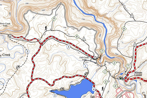
In broken English, they tried to explain that they were looking for the trail to Millikan's Overlook. I showed them where the trail started and explained the route.
They thanked us a few times and I smiled. I smiled because they were so gracious, but also because the map they held was one of my old maps that I drew in the late 1990's.
I don't know if they understood what I was saying, but I told them, "it was my map." They looked puzzled so I clarified, "I drew the map for the Park."
They smiled, we smiled, and walked away. It felt good to see someone using one of my old maps. It still looked good.
Happy Fall Creek Falls storied trails