| 704 | Radnor Lake New Map! |
2012-09-17 |
The new Radnor Lake topo trail map is up on cloudhiking.com. It looks great.
Last year (2011) we updated our map making software. The learning curve was steep, but we are finally getting the hang of it : - ). We now are capable of making a very nice geo-referenced map in a much shorter period of time.
The only problem is, there are just not enough hours in the day to make all of the maps that we would like to make! We have collected tons of data necessary for making new maps, but we still have old maps that we also need to be re-made. Radnor Lake (one of our favorite places) was on the short list for a new geo-referenced map.
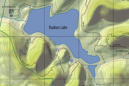
A Cropped Section of the Map
A few Radnor Lake Map notes ...
The Radnor Lake Map was made by importing GIS data into Adobe Illustrator. The map was a vector file then saved as a PDF document.
Users may zoom as close as they want - not on the above map, but on the full map at cloudhiking. The shaded relief background is a pixel based image, but the vector lines do not distort.
The map is under 1 mb and may be saved to smart phones or tablets. (See instructions on the Map Page at cloudhiking.com)
Radnor Lake is always expanding it's boundary which is great news, but as a map maker it is hard to keep up with their expansion. The map used the TDEC Boundary files - January 2011. The boundary has changed since that date.
New information on the map includes the short section of the South Cove Trail that was re-built after the May 2010 Flood.
The new re-route added .05 miles to the South Cove Trail.
Other mileages were adjusted to match the Park's distances.
Map features include: trails, mileage, and a grid.
We debated whether to color the ponds south of Otter Creek Road green! If you have hiked the trails, you would understand - the green-ness was even an "Ask the Ranger" topic on the Friends Site.
We hope the Radnor Lake Map makes you want to hike the trails. Hope to see you there!
Happy Radnor Lake New Map trails
cloudhiking Radnor Lake pages ...