| 572 | Virgin Falls | 2012-02-06 |
Last week, I went to Virgin Falls with a couple of friends, Ray and Robin. They are State Park Rangers and Robin oversees the Virgin Falls Natural Area. It was a pleasure to walk with them.
Coming from different locations, we met in Sparta, TN and then drove together to the Natural Area. We had fun catching up with each other in the short ride.
Virgin Falls is located on the plateau of middle Tennessee. From Sparta, the trailhead is located eighteen miles to the southeast. The roads are in good condition and the area is accessible by passenger vehicles.
From the trailhead we began a gentle descent into the Big Branch drainage. Soon, we crossed the creek and then crossed it again. We followed the slow moving creek until reaching the Big Branch Falls, the first of the falls. It was small but was a sign of other falls to come.
Continuing down steeper terrain, we left Big Branch and joined the banks of Laurel Creek. At a crossing, a wire was rigged to assist hikers. (Use caution.)
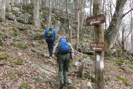
A short distance below the crossing, we came to a junction. The Overlook Trail leaves the Main Trail and climbs to the rim of the gorge. We visited the Overlook on our return hike.
Following Laurel Creek we reached Big Laurel Falls at 2.3 mile. The creek went over the Falls and in a short distance, fell into a sink hole. The disappearing creeks would become a pattern for other falls in the area.
After Big Laurel Falls, the trail left the creek and began contouring west. At a junction the trail became a loop or lollipop - a loop on the end of an out and back trail. We went right and would walk the trail as a loop. At 3.7 miles we came to the Sheep Cave junction. It is a short, worthy hike from the junction to the cave.
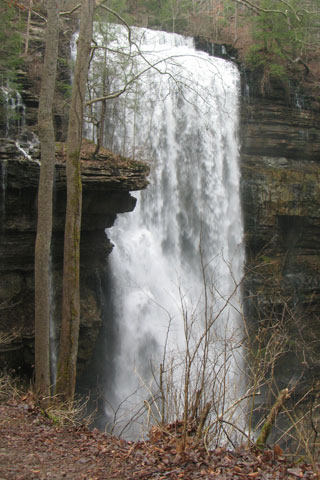
Leaving the Cave area, the trail continues to contour to Virgin Falls. The Falls is 4.25 miles from the trailhead (without any side trips). The walk was easy and the Falls was spectacular.
After a short visit, we left the Falls and followed the loop trail as it continued downhill toward Piney Creek. Following the sings and blazes we were soon climbing a steep ridge out of the river bottom area. (The trail does not go to Piney Creek; but there are plenty of ATV tracks that lead in that direction.)
Steep climb up a rocky ridge
The trail returning to the trailhead was uphill! All the easy downhills were now steep climbs. The contour of the trail really does a good job of keeping the climbs to moderate levels; but the overall trail would probably have to be rated as difficult.
Returning to the Overlook Junction, we took the blue blazed trail to the top of the gorge. One section of the trail climbs a wooden ladder up a drainage. We enjoyed the lookout.
Returning to the trailhead our overall distance was 9.5 miles with 1.30 miles of side trips. Our time for the 9.5 mile hike was 4 hours and 22 minutes. We had time restrains that kept us moving.
This was my first time to the area. Robin said Virgin Falls was the most visited of the Natural Areas (of the ones not also Parks, I am assuming.) I could see why, the falls were spectacular and the hike was challenging; but fun. It is a great place to visit. Oh, but remember, it is a Natural Area and the area is protected by law. Please, tread lightly and Leave No Trace.
Happy Virgin Falls trails
Virgin Falls Natural Area (Official Page)