| 573 | Warner Parks Map - Revised | 2012-02-07 |
On cloudhiking we have improved our map making capabilities with the use of ESRI, Geographic Imager, and Map Publisher programs. All of our new maps are geo-referenced. We have also revised two of the original maps - Bells Bend and Warner Parks to meet our new standards. We are still learning and improving. We hope you enjoy them!
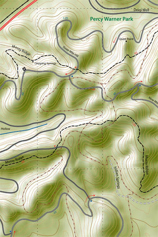
A few notes about the Warner Parks map ...
The old maps were divided into the Percy Warner map, the Edwin Warner map, and the Harpeth River Greenway. The new map includes all three maps.
We did not remove the old Warner Park maps from the site.
The new map is visually large. The file size still remains well under a megabyte of data.
The map is designed to view on a computer, tablet, or smart phone.
On the computer - just open the map in the browser or download the map to your computer. Open the map with a pdf viewer.
On a smart phone or tablet, the easiest way (currently) to view the map is to open a pdf reader, such as iBooks, and download directly to the App.
(Sorry, we only use Apple products; but I am sure there are similar pdf readers for the Android platform.)
The three major trails Warner Woods (white blazed), Mossy Ridge (red blazed), and Harpeth Woods (blue blazed) are loop trails. Most of the times when the trails are walked, connector mileages also have to be added. The added connector mileage causes some differences in the exact mileage for the trails.
Doing the July 4th walk or run, (red, white, and blue trails) from Belle Meade Boulevard, with a stop at the Nature Center for water and a restroom break, is about 12.15 miles.
We tried to clearly show the Old Roadway in Edwin Warner and the 5.8 and 11.2 road routes in Percy Warner. These are great routes.
Bridle Path mileages were not included. The Bridle Paths indicated on the maps are only estimates and they are the only data on the map not checked with a gps. We just included the paths as reference.
The Hill Property will be added to the map as soon as the addition is opened to the public.
Happy revised trails
Thanks for your support.
Warner Woods, Mossy Ridge, Harpeth Woods, Harpeth Greenway, Five-Eight