| 784 | Longs Peak Map | 2013-03-18 |
For three years, we have been making maps on cloudhiking.com. As our skills have slowly improved, we have attempt increasingly more difficult maps. Finally, we attempted and completed Longs Peak. The map was almost as difficult as climbing the peak but finally we are standing on the summit!
One of the problems with the map was wading through all of the data. We are very familiar with the mountain.
As a youngster I failed to climb the mountain on my first two attempts. Then through the years my success rate improved and I climbed the peak 37 times by a total of 9 different routes. Each year I look forward to completing at least one route on Longs.
When my wife and I were still just dating, we climbed the Keyhole together. She swore she would never climb a 14er again, well at least until the next summer! She has climbed Longs 7 times by 3 routes.
In the recent years as we have been mapping, we have carried a GPS and camera with us and gathered data of the routes and trails. We also have a large collection of books and guidebooks on the peak. Through the years, we have collected quite a mass of data, but that does not necessarily make the map easier.
We can't wait for summer to use the map. Now that the basic routes are completed, this summer we will be checking the lines and adding more routes to the map. One of the fun things about an online edition of a map is that it is easy to update.
Now, for a few Longs Peak Map notes ...
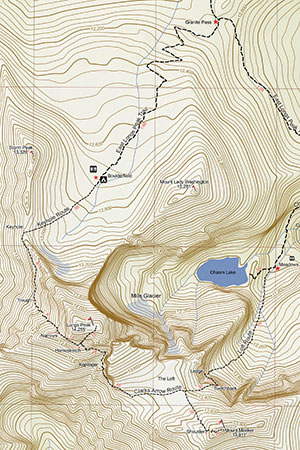
The map covers parts of the Allens Park, Isolation Peak, Longs Peak, and McHenry quadrangles.
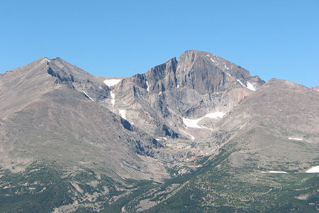
The map includes the standard routes on Longs Peak and Mount Meeker.
The East Longs Peak Trail travels 5.9 miles to the Boulderfield. The Boulderfield is a worthy destination. The trail is excellent.
The Chasm Lake Trail is a spur that leads to the pristine lake lying below the mighty Diamond of Longs.
An interesting opportunity with map making is to find two sets of data that agree. The contradicting data is most obvious with mileage. Most trail mileage is measured by the actual foot on the ground distance instead of the closest distance between two points. An as the crow flies distance is always the same, but the actual distance can widely vary. The problem is, that there is no correct route and thus no real number. One track's distance might be twice that of another and they are both correct! We tried to use the higher mileages for our data.
We tried to include numerous waypoints.
Longs Peak is a mountain and is dangerous to climb. Hikers die on the mountain almost every year. Learn to be a mountaineer and once competent practice your skills on the mountain.
Please use the map this summer and tell us what you think!
Happy Longs Peak Map trails
cloudhiking home page
other journal entries ...