| 477 | Summer Stories - Navigating with a Map or Not |
2011-09-16 |
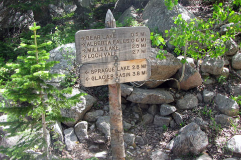
On my first day in Rocky Mountain National Park this summer ('11), I was walking the Glacier Creek Trail. The trail is a major artery connecting Glacier Basin Campground to Bear Lake; but it is not heavily traveled.
A few miles into the hike I saw a group of hikers standing to the side of the trail looking at a lily pond. I nodded as I passed; but paused when I overheard a woman in the group say, "I guess we are about a tenth of a miles from Alberta Falls."
After talking with them for a few minutes, I discovered that grandma was taking the kids on a hike to Alberta Falls, the only problem was they were not on the trail to Alberta Falls. They had made a wrong turn.
My short visit with the family was a wonderful experience. Grandma was the only one who was upset about her navigational error. She had visited the falls earlier in the week and really wanted to show the kids the magnificent falls.
Where Grandma made her navigating error was at a junction, a short distance from the trailhead. The area can be very crowded. There are signs; but if the area is congested the signs would be easy to miss. When I saw the family they had already walked farther in the wrong direction than they would have walked to reach the falls. That's too bad, because grandma was right, the falls were magnificent.
So how could you make a wrong turn on a trail? Well I think it is pretty common. I know I have done it several times myself by just not thinking about what I was doing. Perhaps I was talking or deep in a trance and then find myself going the wrong direction. Other times after walking a short distance on the trail I begin to question whether I made the right turn or not. I then, retrace my steps to confirm that I made the right decision. I solved my wrong turn mania by practicing simple map navigation.
So here are a few navigating tips ...
Grandma had a lot of trail sense. When she said she was a tenth of a mile from Alberta Falls, she was directing the comment to me. She knew she was not where she wanted to be, but did not know where she was. She was asking for help.
It is okay to make navigating mistakes. The trick is to catch the mistakes early.
To avoid losing your way, carry a map and refer to it often.
Most folks do not know how to use a compass, but one key use is to orient (or align) the map to the compass. Find north on the compass and turn or orient the map so that it faces north also. For some folks, the simple orienting the map procedure helps them to see the landscape better.
Before you start on the hike, familiarize yourself with the trail on the map. If your trail is not on the map, you will need more navigational skills than simple map navigation to safely travel through the unmarked terrain.
While on the trail, at every junction look at the map and confirm your location.
At junctions, also note where all the other trails lead.
At stream crossings and other easily identifiable features or landmarks, confirm your location on the map.
The map needs to be easily accessible.
It is okay to place marks on the map.
To practice map navigation, you need to carry a topographical map.
Discuss all navigating decisions with the group.
I almost always carry a map even when I am carrying a GPS.
Navigating with a map is not hard. It does take practice; but it is worth the effort. Of course you can always speak very loudly to passing hikers and hope they will help you.
Happy navigating with a map trails
see also - Ten Essentials - Navigation