| 667 | Syncline Loop Trail | 2012-06-27 |
After a relatively easy day of exploring and hiking to Delicate Arch, we were ready for a longer day.
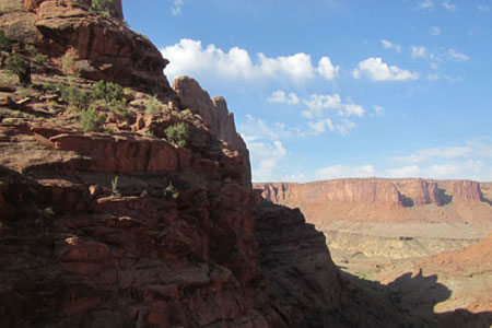
Waking early we left Moab and drove to the Island in the Sky District of Canyonlands National Park. The Island in the Sky sits north of the confluence of the Green and Colorado Rivers. From the high Island plateau, there are many viewpoints of the rivers below. Driving south from Hwy 191 on Hwy 313, the scenic road weaves through buttresses and mesas. A Visitors Center is located close to the Park entrance. (It is the only location for water.) Crossing a bridge at the "Neck" put us on the Island, in the sky.
Continuing we drove to the Upheaval Dome area, the trailhead for our hike, the Syncline Loop. The area had shaded picnic tables and a relatively large parking area. There were also privies, but no water.
Leaving the trailhead, we came to a junction, the Syncline Trail is a loop trail, so we were able to choose which direction we wanted to walk. We turned right or north and began the loop traveling counter-clockwise.
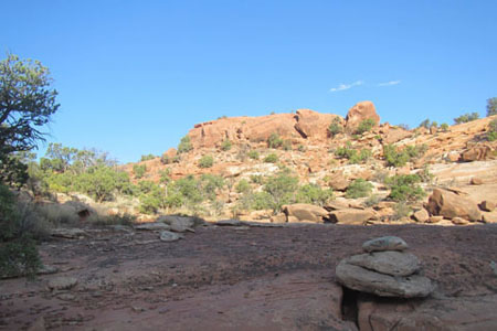
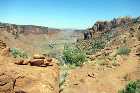
Shortly after the junction, the trail begins following a wash. The easy path was marked frequently with rock cairns (stacks of rocks). We were continually trying to guess exactly where the path was going. If we had just thought it follows the wash, we would have always been right. Sometimes the path led around an obstacle, but it always followed the general direction of the wash as it circled the Upheaval Dome.
We made good time as we dropped lower into the wash, but of course it was in the cool morning air and we were going downhill. Coming to an obvious buttress blocking our passage, we turned right and went even lower into the wash, but the descent was just beginning. A seasonal spring/creek was followed as we entered Syncline Valley.
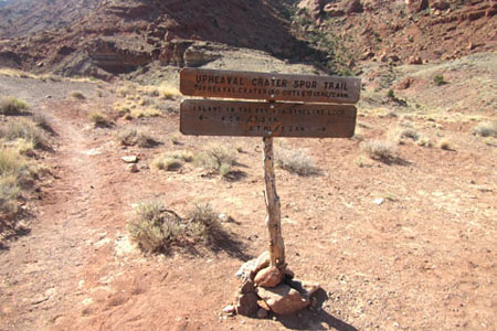
Looking ahead we could see the trail, far away in the Valley. That was where we were going. The descent was steep and required sections of scrambling (using your hands) and route finding (or looking for cairns). It was a fun section, but we knew what goes down, must go up and it was only going to be hotter. In the lower wash, we continued circling the dome as we passed the Syncline backcountry camping site and came to a junction with the Upheaval Crater Spur Trail. At this point we should have consulted our map, but the directions were clearly signed. From the sign we saw we had traveled 4.6 miles and only had 3.7 miles to go. Each moment we wasted, was a moment longer we would hike at increasingly hotter temperatures. The spur trail sounded very interesting, but adding 3 miles round trip to our venture, was a bit too much. With no hesitation, we followed the sign toward our destination.
Shortly after leaving the junction, the trail dropped into another wash, but on the other side the trail faded into the hill. We stopped and searched for the trail. The cairns were gone and the path was faint and at times only footprints. As we sweated our way higher to the crest of a distinct ridge, we knew we had lost the trail. Looking far below, we saw a trail and began the long trailless descent. Reaching the wash, we knew we had to go to the left to continue our loop, but I had to see what why we missed the trail. I left Amy and followed the trail we were supposed to have walked to our last known point the junction sign - a mile distance - one way.
Re-arriving at the junction with the spur trail, I looked at the sign. It pointed us in the wrong direction and enough hikers had gone the wrong direction to make a trail. The one unmarked trail leading from the junction was the correct one to follow. Go figure.
Though I hurried on my side trip, by the time I returned to Amy, she was worried and was preparing to come looking for me. Hardly ever is it a good idea to split the group. I was glad that it was not me having to sit and wait for my partner.
Continuing our journey, we began walking up the wash. That's right at a junction down-wash (okay I made that up - further down the drainage) from us two washes or dry creeks joined which continued to the Green River. We were now walking up-wash on our shorter return trip to the trailhead.
Still gently climbing the lower wash, we met four hikers. One was not even carrying a pack. These were the first hikers we had seen in over five miles!
We knew we were going to have to make a steep climb out of the lower wash. After several wrong guesses as to where the trail would go, we finally started the climb and were treated to a great path. A newly constructed trail led through numerous switchbacks as it climbed a steep slope tamed to a moderate grade. Amy and I both said, well done to the trail builders.
At the top of the slope, we met easier terrain, but the full fury of the sun. We met several groups of hikers who had just started their trek and were headed downhill. They were so chippery, it was disgusting, but they basically only walked downhill and they did not yet understand the commitment of the trail. It was very similar to the folks we met while walking the Bright Angel Trail in Grand Canyon.
The last mile of the trail was the toughest for us. It was very difficult mentally. The trail was not steep, but it seemed to wander and we grew hotter with every step.
Rising over one last crest, we finally saw the parking area. Discipline kept us on the trail as we wanted to shortcut a beeline to the vehicle. Lots of people were sitting in the cool shaded picnic shelters eating or drinking coolness. We were hotter than blazes and did not even have our cooler or any cool beverages with us. We had to settle for tepid water, but we were ready to go from shelter to shelter begging for ice.
After knocking a few pounds of dust and dirt from our legs, we drove away and continued our tour of the Island in the Sky. We made a commitment to return someday. We really enjoyed ourselves, except for the heat. The Island was far less crowded than Arches and had a great little campground. It was our kind of place.
Happy Syncline Loop trails
Note: We did report the confusion with the junction sign. If still unchanged, it would only effect those hiking the loop counter-clockwise. So lesson #93321 - even at signed trail junctions, get out the map and double check - the sign could be wrong!