| 577 | Trail Sense GPS Navigation |
2012-02-13 |
So you have a GPS, you can now pinpoint where you are on the face of the earth to within a few meters. Gone are the days of having to triangulate your position with a map and compass, the GPS does it all for you. Well, sometimes, if you know how to use it.
I had a GPS for years before I became a real user. I could tell that the GPS was giving me information; but using the device was not easy to use and I felt it was inaccurate.
Part of the problem with my GPS use was because I used a Mac computer and hardly any of the GPS software was made for the Mac. I even went so far as to run Windows on my Mac, just so I could load the maps onto the GPS. Still, I limited using the GPS computer programs, because it was a pain to switch back and forth from Windows to Mac.
Finally, Garmin made their BaseCamp for the Apple users! In the mean time, I had begun to use a third party's software, Mac GPS Pro. The small company in Colorado makes a good product.
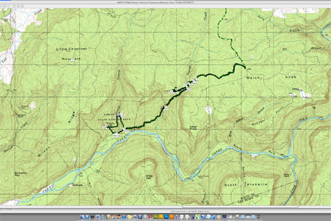
The GPS software takes the GPS to the next level. A GPS will show your location; but without the computer, the GPS is sometimes painfully slow to use. On the computer screen, you can quickly load a map (many of them for free, see below), set waypoints and a route, and upload the information to your GPS for use on the trail.
Taking your loaded GPS to the field, you have a route to follow, that you made. If you decide to venture off the track, you can still easily return to the intended route.
The GPS is a wonderful navigation tool. The computer software makes navigating with the GPS even easier. As you experiment, you will learn tricks that will make the GPS an even better tool.
Now for a few GPS navigation tips ...
Carry a map, paper map and a small compass with you. You still need to know how to use the map and compass.
You can download GPS tracklogs and waypoints from sites such as Backpacker.
A route consists of waypoints and a tracklog.
The more waypoints that you add, the more accurate the route.
Using the computer, entering a waypoint is as simple as pushing the 'enter' button. It is that easy on the GPS too; but the computer is used to plan the route for the trip.
You can make a route using just the GPS; but it is so much easier to do so using the computer, Mac or PC.
In setting the waypoints on the computer, add waypoints at all known key locations (taken from the map).
The GPS can give you estimated time and the distance to each waypoint.
Following the track, it is easier if you change your view (from the settings) from north up to heads up or tracks up.
If you are walking on an obvious trail, following a track that you downloaded, and the track does not match the trail ... do not fret, one of the tracks is not very accurate. Just stay on the trail, that is where the track should be. In an area of poor coverage the error may be quite large. The (inaccurate) track is still useful is showing the general shape of the route. With a better view of the sky, the track's accuracy will improve.
By making a route on the computer, it eliminates the problems with accuracy of a tracklog (downloaded from another GPS user.) Your GPS track might still be inaccurate; but that is an easier correction, than having two inaccurate GPS tracks.
When one track is inaccurate due to poor coverage, the other tracks will most likely be inaccurate too.
With experience you will find what information you will need on your hikes and how to make your routes accordingly.
I have told a story many times about when I first started using a GPS. After using a map and compass for years, it was hard to believe that the GPS could make navigation so easy. Then, with more use, I found that the GPS was inaccurate. Sometimes my position was up to a hundred or so feet off. While standing still and watching the GPS screen, my position would even change! I quit using the GPS for awhile; but then started thinking about my navigation accuracy while using a map and compass. If I plotted my position with map and compass as many times at the GPS was doing, the track of my position would also be jumping around!
I started using the GPS again, and embraced the errors. When I no longer blindly followed the GPS and used my other navigation skills and common sense, I was able to develop a hybrid navigation system. The GPS is the primary tool of the system; but after years of field use, I developed checks and balances to help keep me on course - or not too far off!
Happy navigating trails