| 762 | best of cloudhiking |
2013-01-25 |
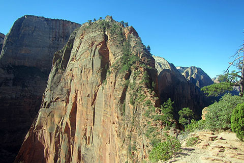
Angels Landing - Zion National Park
Continuing on the picks from the Metro to Mountain and cloudhiking sites for our favorites of the year 2012, we are choosing our favorite cloudhiking Adventure Guides and Maps.
During the year we walked many trails, paths, and greenways. After completing an adventure we would decide if we wanted to work the data we collected into an Adventure Guide, Map, or both. There were a few trails or routes that we chose not to develop into guides. There were many trails that we liked but just did not have time to finish the work. All of the areas that we published as an Adventure Guide or Map were winners to us. Choosing on a selection for the best was not easy, as there was but a small difference between our picks.
Our Top cloudhiking Entries for Mountains (Map or Map and Adventure Guide)
- Angels Landing - Zion National Park, Utah - (Map and Guide) Angels Landing in Zion National Park quickly became one of our favorites. We had read many reports of the route before our visit which led to big expectations, but if anything Angels Landing was better than expected. This route is not a hike, please heed all warnings. The cloudhiking map of Angels Landing is beautiful and maybe one of our best. The pictures and guide let you experience the route. Whether you have done the route before or just dream of a visit, the guide will wrap you in adventure!
- Barr Trail - Pikes Peak, Colorado - (Map and Guide) Barr Trail is a five star trail. Starting in Manitou Springs, the trail travels through the foothills and reaches Barr Camp, the halfway point. Continuing to climb, the trail finally breaks out of the trees and enters the alpine tundra as it crisscrosses the East Face of Pikes Peak. After about 12 miles the trail finally reaches the summit where it enters a continuation of the Manitou Springs tourism experience. Don't hold the tourist effect against the Barr Trail, instead, embrace the capitalism - walk straight inside the gift shop and buy coffee, donuts, and a few Pikes Peak trinkets. The map and guide are large, but so is the trail. Enjoy.
- La Luz Trail - Sandia Mountains, New Mexico - (Map and Guide) East of Albuquerque the Sandia Mountains dominate the skyline. From the valley, the range seems as if it has a cliff band blocking any hiking route from the west side. As unpredictable as it seems, the La Luz Trail winds through rock spires, walls, and boulders and eventually finds the summit of the Crest. The trail is very popular and similar in many ways to the Barr Trail. There is a gift and snack shop at the summit of Sandia Mountain and both Barr Trail and La Luz Trail are also very popular trail runs. The Map and Guide mark the key mileages and waypoints. The trail is rated as difficult, but is still a very worthy objective.
Our Top cloudhiking Entries for Trails (Map or Map and Adventure Guide)
- Fall Creek Falls State Park - Tennessee - (Map Only) Fall Creek Falls is a large State Park in the center of Tennessee. Like the Park, the map is large, but still does not encompass the entire Park. The map focuses on the trails, not just the land. When more trails are added, the map will probably be revised to include the new pathways. The gorges in the Park make for great relief and add a 3D like dimension to the map. It looks great. We have not yet made a guide to the trails, but maybe this year!
- Warner Park - Nashville, Tennessee - (Map Only) Warner Parks is one of the great local, Nashville, parks. The well visited park has many trails and roadways. The map includes road distances for the many walkers, runners, and bicyclists and trail distance for the many hikers and trail runners. Also included in the map is the new Hill Tract. The map will be revised as the trails grow to the new lands.
- Virgin Falls State Natural Area - Tennessee - (Map and Guide) Last year was my first visit to the natural area. On seeing the great falls, we had to make a map and guide to the area. Virgin Falls is unique and truly a natural wonder of Tennessee. The beautiful map and guide represent the area well. You must go for a visit to appreciate it.
Happy 2012 trails